Property Information
Own 334+ Acres of land located south east of Route 17B and County Rd 113 in the town of Cochecton, NY. The land is 3 miles west of Museum of Bethel Woods the site of Woodstock and a year round concert desitination and Performing Arts center. Several locations within a 15 mile radius have been proposed sites for gambling casinos (Concord / Monticello / Kutschers).
Property is located in Cochecton, Sullivan County, NY; the heart of the Catskill Mountains. The property consists of 336+/- acres raw land that is prime for development.
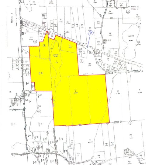
- The entire parcel encompasses 5 individual tax lots. The property was formally known as Eiffert’s Pond. The property features a 21.6 acre pond. Further, there are numerous horseback riding trails throughout the land. The property has a fairly flat topography, good soil and there are minimal wetlands.
- 310.69 +/- acres are zoned Rural Development (RU). Permitted principal uses for this zoning include, but are not limited to single family dwelling, two family dwelling, bed and breakfast facility, agricultural uses, and hunting and fishing lodges. The minimum lot area is 2 acres, leaving a tremendous opportunity to subdivide. 25.76 +/- acres of the property are zoned Hamlet District (HD), which is provides for limited development. Properties zoned within HD area are typically gas stations, hotels / motels, retail centers, restaurants, etc. This zoning also has a 2 acre minimum.
- Legal Information (5 tax lots): Section: 11 Block : 2 Lot: 2 232.89 +/- acres 2400-011-0-0001-002-000 2400-011-0 ¾ Census Tract/Block: 9522.00 / 2 ¾ Lot Size: ¾ APN: ¾ Map Reference: ¾ Zoned: RU Rural Development ¾ Note: Parcel has 364’ +/- of road frontage on Rte 17B according to the zoning map. Section: 9 Block : 2 Lot: 22 56.20 +/- acres 2400-009-0-0002-002-002 2400-009-0 ¾ Census Tract/Block: 9522.00 / 1 ¾ Lot Size: ¾ APN: ¾ Map Reference: ¾ Zoned RU Rural Development ¾ Note: Parcel has right of way to Shortcut Rd which offers principal access. Section: 11 Block : 1 Lot: 1 21.60 +/- acres 2400-011-0-0001-001-000 2400-011-0 ¾ Census Tract/Block: 9522.00 / 2 ¾ Lot Size: ¾ APN: ¾ Map Reference: ¾ Zoned: RU Rural Development
- Note: Parcel consists of a pond . Section: 3 Block : 2 Lot: 10 13.36 +/- acres 2400-003-0-0002-010-000 2400-003-0 ¾ Census Tract/Block: 9522.00 / 1 ¾ Lot Size: ¾ APN: ¾ Map Reference: ¾ Zoned: HD Hamlet District ¾ Note: Parcel has 86’ +/- of road frontage on Rte 17B according to the zoning map. Section: 3 Block : 2 Lot: 13 12.40 +/- acres 2400-003-0-0002-013-000 2400-003-0 ¾ Census Tract/Block: 9522.00 / 1 ¾ Lot Size: ¾ APN: ¾ Map Reference: ¾ Zoned: HD Hamlet District ¾ Note: Parcel has 817’ +/- of road frontage on Rte 17B according to the zoning map.
Lot Details
Lot 01
APN: 2400-011-0-0001-002-000
Map Reference: 2400-011-0
Census Tract/Block: 9522.00 / 2
Zoned: RU Rural Development
Note: Parcel has 364’ +/- of road frontage on Rte 17B according tothe zoning map.
Lot Size 232.89 ac
Section: 11 Block : 2 Lot: 2APN: 2400-011-0-0001-002-000
Map Reference: 2400-011-0
Census Tract/Block: 9522.00 / 2
Zoned: RU Rural Development
Note: Parcel has 364’ +/- of road frontage on Rte 17B according tothe zoning map.
Lot 02
APN: 2400-009-0-0002-002-002
Map Reference: 2400-009-0
Census Tract/Block: 9522.00 / 1
Zoned: RU Rural Development
Note: Parcel has right of way to Shortcut Rd which offers principal access.
Lot Size 56.20 ac
Section: 9 Block : 2 Lot: 22APN: 2400-009-0-0002-002-002
Map Reference: 2400-009-0
Census Tract/Block: 9522.00 / 1
Zoned: RU Rural Development
Note: Parcel has right of way to Shortcut Rd which offers principal access.
Lot 03
APN: 2400-011-0-0001-001-000
Map Reference: 2400-011-0
Census Tract/Block: 9522.00 / 2
Zoned: RU Rural Development
Note: Parcel consists of a pond.
Lot Size 21.60 ac
Section: 11 Block : 1 Lot: 1APN: 2400-011-0-0001-001-000
Map Reference: 2400-011-0
Census Tract/Block: 9522.00 / 2
Zoned: RU Rural Development
Note: Parcel consists of a pond.
Lot 04
APN: 2400-003-0-0002-010-000
Map Reference: 2400-003-0
Census Tract/Block: 9522.00 / 1
Zoned: HD Hamlet District
Note: Parcel has 86’ +/- of road frontage on Rte 17B according to thezoning map.
Lot Size 13.36 ac
Section: 9 Block : 2 Lot: 22APN: 2400-003-0-0002-010-000
Map Reference: 2400-003-0
Census Tract/Block: 9522.00 / 1
Zoned: HD Hamlet District
Note: Parcel has 86’ +/- of road frontage on Rte 17B according to thezoning map.
Lot 05
APN: 2400-003-0-0002-013-000
Map Reference: 2400-003-0
Census Tract/Block:9522.00 / 1
Zoned: HD Hamlet District
Note: Parcel has 817’ +/- of road frontage on Rte 17B according tothe zoning map.
Lot Size 12.40 ac
Section: 9 Block : 2 Lot: 22APN: 2400-003-0-0002-013-000
Map Reference: 2400-003-0
Census Tract/Block:9522.00 / 1
Zoned: HD Hamlet District
Note: Parcel has 817’ +/- of road frontage on Rte 17B according tothe zoning map.
Tax Map
Call Today
Interested? Call today for more details.
+1 (516) 967-4770 | +1 (516) 366-2817